In June 2026, Google quietly released one of the most significant geospatial datasets in years: Open Buildings 2.5D Temporal. It covers 50+ countries across Africa, South Asia, Southeast Asia, and Latin America — and it does something no previous open building dataset could: it tracks how buildings change over time and estimates building height.
This isn't just a bigger dataset. It's a signal. Building footprint extraction using AI has crossed the chasm from research novelty to operational infrastructure. When Google — not a geospatial startup, but a trillion-dollar company — invests in releasing temporal building data for half the planet, the message is clear: building footprints are a foundational data layer for the AI era, as essential as roads and addresses.
In this article, we break down what Open Buildings 2.5D offers, why it matters, where it falls short, and how commercial-grade AI building detection (like WetuneAI) fills the gap for real-world applications.
What Makes 2.5D Temporal Different
Previous versions of Google's Open Buildings dataset (released 2021-2023) were fundamentally 2D snapshots: flat polygons showing building outlines at a single moment in time. Version 2.5D Temporal adds three game-changing dimensions:
1. Height Estimation (the "0.5" in 2.5D)
Every building polygon now comes with an estimated height, derived from monocular satellite imagery using deep learning. While not as precise as LiDAR, this is transformative for population density modeling, solar potential analysis, and 5G tower planning — all of which need to know not just where buildings are, but how tall they are.
2. Temporal Change Tracking
The dataset spans 2016 to 2023, showing which buildings appeared, which disappeared, and which stayed. This enables change detection at continental scale: urban expansion rates, informal settlement growth, disaster recovery patterns, and construction booms — all visible through the lens of building footprints.
3. Confidence Scores
Every prediction carries a confidence score, letting data consumers filter by quality threshold. This is crucial for applications where false positives (detecting a building where none exists) carry real consequences — like insurance underwriting or property taxation.
Why Building Footprints Are the New Postal Address
For decades, roads and addresses were the fundamental spatial reference layer. But in much of the Global South — the very region Google's dataset targets — formal addressing systems are incomplete or nonexistent. An estimated 4 billion people lack a physical address.
Building footprints solve this: every building becomes a geospatial identifier. Combine footprints with height, and you get population estimates. Combine them with temporal data, and you get urban growth rates. Add roof material classification, and you get economic indicators.
This is why Google, Microsoft (via their Building Footprints project), Meta, and national mapping agencies are all investing in building footprint extraction. When the world's largest tech companies treat building data as open infrastructure, we've crossed a threshold.
Where Open Datasets Fall Short — and Where Commercial AI Excels
Google's dataset is incredible for what it is: a free, continental-scale resource for researchers, NGOs, and governments. But it was not designed for commercial applications that demand precision, recency, and custom outputs.
| Capability | Google Open Buildings 2.5D | Commercial AI (WetuneAI) |
|---|---|---|
| Imagery source | Medium-res satellite (10m Sentinel-2) | High-res drone & aerial (3-5cm GSD) |
| Polygon accuracy | ~85% IoU | 95%+ IoU |
| Update frequency | Static (2016-2023 batch) | On-demand, near real-time |
| Coverage | Global South only | Anywhere with imagery |
| Height accuracy | Estimated from 2D (RMSE 3-5m) | Photogrammetric (RMSE <0.5m with GCPs) |
| Building attributes | Polygon + height only | Roof type, condition, material, area |
| Custom training | Not available | Fine-tuned for client-specific needs |
The key difference is resolution of input imagery. Google's model operates on medium-resolution Sentinel-2 satellite data — sufficient for detecting building presence across continents, but insufficient for precise boundary delineation, roof condition assessment, or small structure detection. Commercial solutions using drone or high-resolution aerial imagery operate at 3-5 cm per pixel — roughly 200x the detail.
Six Industries That Need Building Footprint AI Now
Based on industry surveys and WetuneAI customer deployment data, Q1-Q2 2026
Urban Planning & Smart Cities
City planners need to know what exists before they can plan what's next. Building footprint extraction automates base-map creation, zoning compliance checks, and density analysis. Temporal change detection reveals where the city is growing fastest — and where infrastructure needs to catch up. See our deep dive on AI building segmentation for sustainable urban planning.
Insurance Underwriting
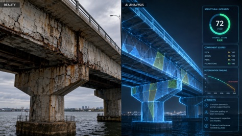
Property insurers are increasingly using building footprints for portfolio risk assessment: roof area, building density, proximity to flood zones, and construction type — all extractable from aerial imagery without sending inspectors to every site. After disasters, AI-powered rapid building damage assessment can process thousands of structures in hours.
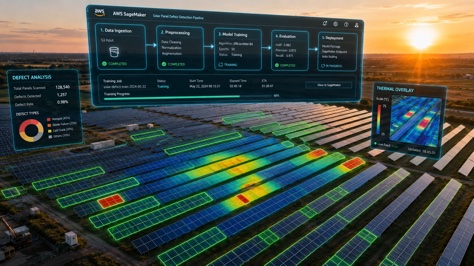
Solar Energy Site Assessment
Rooftop solar potential is fundamentally a building detection problem: you need accurate roof polygons, orientation, slope, and shadow analysis. AI building segmentation processes entire cities in days, identifying every viable rooftop and its solar capacity.
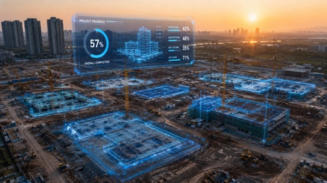
Construction Progress Monitoring
For large-scale infrastructure projects, weekly drone flights + AI building detection provide automated progress reports: which foundations are poured, which structures are at what stage, and whether the schedule is on track — all derived from building footprint changes between flights.
Telecommunications
5G and fixed-wireless network planning requires line-of-sight analysis that depends on building height and density. Building footprint data with height attributes turns weeks of manual site surveys into automated desktop analysis.
Disaster Response
When earthquakes, floods, or hurricanes strike, responders need to know what was there before and what's damaged now. Temporal building footprint comparison — before/after satellite or drone imagery — enables rapid damage assessment at scale.
What's Next: From 2.5D to True 3D
Google's 2.5D dataset is an important step, but the industry is already moving toward full 3D building models: detailed roof geometry, facade classification, window and door detection, and even interior layout estimation from external imagery. The combination of AI segmentation, photogrammetry, and LiDAR is making city-scale 3D twins a reality — not just for tech giants, but for any organization with drone or aerial imagery.
As we explored in our article on AI building detection for digital twins, the foundation of any smart city digital twin is accurate, up-to-date building data. Google's investment validates this thesis at the highest level.
The next frontier is real-time change detection: continuous monitoring pipelines that flag new construction, demolition, or structural changes within days — not years. This requires the kind of on-demand, high-resolution processing that commercial AI platforms provide.
Frequently Asked Questions
Ready to Extract Building Footprints from Your Imagery?
Upload drone or aerial imagery and get accurate building footprints in minutes — no GIS expertise required.
Try WetuneAI for Free →